|
POLYGON ((29.13981 -22.21556, 29.13925 -22.21533, 29.13981 -22.21556, 29.14002 -22.21565, 29.14029 -22.21579, 29.14073 -22.21598, 29.14147 -22.21612, 29.14225 -22.21627, 29.14256 -22.21634, 29.14281 -22.21632, 29.1433 -22.21643, 29.14442 -22.21648, 29.1454 -22.2165, 29.14629 -22.21636, 29.147 -22.21632, 29.14778 -22.21622, 29.14857 -22.2161, 29.14955 -22.21595, 29.15003 -22.21589, 29.15053 -22.21574, 29.15108 -22.21566, 29.15219 -22.21534, 29.15307 -22.21514, 29.15377 -22.21492, 29.15435 -22.21472, 29.155 -22.21452, 29.15547 -22.21429, 29.15577 -22.21407, 29.15601 -22.21392, 29.15651 -22.2136, 29.15707 -22.21334, 29.15764 -22.21301, 29.15846 -22.21248, 29.1591 -22.21189, 29.15956 -22.21138, 29.15984 -22.21084, 29.16038 -22.21018, 29.16075 -22.2099, 29.16147 -22.20954, 29.16183 -22.20934, 29.16217 -22.20919, 29.1627 -22.20897, 29.16321 -22.20873, 29.16413 -22.20839, 29.16476 -22.20812, 29.1653 -22.20785, 29.16568 -22.20763, 29.16616 -22.20736, 29.16643 -22.20713, 29.16663 -22.20696, 29.16724 -22.20648, 29.16807 -22.20582, 29.16917 -22.20494, 29.16991 -22.20438, 29.17041 -22.20396, 29.17123 -22.20325, 29.17184 -22.20285, 29.17253 -22.20237, 29.17303 -22.20206, 29.17343 -22.20167, 29.17389 -22.20118, 29.17447 -22.20063, 29.17518 -22.19976, 29.17556 -22.19923, 29.17603 -22.19871, 29.17653 -22.19819, 29.17719 -22.19759, 29.17758 -22.19703, 29.17809 -22.19628, 29.17833 -22.19579, 29.17869 -22.19537, 29.17885 -22.19511, 29.17918 -22.19466, 29.17956 -22.19412, 29.18002 -22.19352, 29.18027 -22.19317, 29.18054 -22.19281, 29.181 -22.19245, 29.18194 -22.19175, 29.1826 -22.19139, 29.18317 -22.19117, 29.18344 -22.19105, 29.18441 -22.19071, 29.18536 -22.19033, 29.18594 -22.19009, 29.18659 -22.18981, 29.1873 -22.18944, 29.18781 -22.18905, 29.18817 -22.18871, 29.18849 -22.18817, 29.18874 -22.18772, 29.18891 -22.18734, 29.18916 -22.18696, 29.18944 -22.18672, 29.18969 -22.1865, 29.19006 -22.18624, 29.19035 -22.18605, 29.19077 -22.1858, 29.19106 -22.18566, 29.19151 -22.18545, 29.19179 -22.18534, 29.19294 -22.18488, 29.19332 -22.18469, 29.19379 -22.18448, 29.1941 -22.18434, 29.19458 -22.18412, 29.19504 -22.18402, 29.19572 -22.18382, 29.19626 -22.18372, 29.19694 -22.18359, 29.19739 -22.18352, 29.19795 -22.18339, 29.19841 -22.18332, 29.1988 -22.18325, 29.19969 -22.1832, 29.20019 -22.18317, 29.2008 -22.18312, 29.20155 -22.18306, 29.20212 -22.18301, 29.20322 -22.183, 29.20439 -22.18293, 29.20489 -22.18291, 29.20589 -22.18273, 29.20643 -22.18268, 29.20751 -22.18268, 29.20816 -22.18266, 29.20857 -22.1826, 29.20892 -22.18255, 29.20935 -22.18249, 29.20985 -22.18235, 29.21031 -22.18224, 29.21075 -22.18216, 29.21148 -22.18198, 29.21173 -22.18188, 29.21234 -22.18156, 29.21265 -22.18133, 29.21324 -22.18099, 29.2138 -22.18056, 29.21435 -22.18007, 29.21487 -22.17951, 29.21529 -22.17918, 29.21594 -22.17879, 29.21662 -22.17847, 29.2172 -22.17831, 29.21769 -22.17827, 29.21824 -22.17817, 29.2189 -22.1781, 29.21957 -22.17816, 29.22004 -22.17818, 29.2204 -22.17819, 29.22118 -22.17822, 29.2219 -22.17825, 29.22265 -22.17833, 29.22352 -22.17841, 29.22446 -22.1785, 29.22479 -22.17854, 29.2253 -22.1786, 29.22562 -22.17864, 29.22608 -22.17869, 29.22696 -22.17883, 29.22754 -22.17897, 29.22792 -22.17906, 29.22847 -22.17924, 29.22888 -22.17934, 29.22942 -22.17949, 29.22987 -22.1796, 29.23019 -22.17968, 29.23053 -22.17973, 29.23084 -22.17978, 29.23122 -22.17986, 29.23145 -22.17992, 29.23214 -22.18007, 29.2327 -22.18021, 29.23303 -22.18023, 29.23361 -22.18041, 29.2342 -22.18062, 29.23488 -22.18079, 29.23571 -22.18099, 29.23683 -22.18131, 29.23829 -22.18182, 29.23901 -22.18233, 29.23948 -22.18269, 29.23965 -22.18281, 29.24004 -22.18305, 29.24041 -22.18318, 29.24062 -22.18325, 29.24118 -22.18354, 29.24156 -22.18367, 29.24191 -22.18394, 29.2423 -22.18424, 29.2426 -22.18449, 29.24292 -22.18475, 29.24335 -22.18502, 29.24373 -22.18526, 29.24411 -22.18547, 29.24448 -22.18568, 29.24514 -22.18614, 29.2454 -22.1863, 29.24572 -22.18648, 29.24617 -22.18671, 29.24644 -22.18684, 29.24687 -22.18698, 29.24732 -22.18713, 29.24773 -22.18728, 29.24808 -22.18741, 29.24849 -22.18769, 29.24889 -22.18778, 29.24932 -22.18792, 29.24983 -22.18809, 29.25064 -22.1886, 29.25113 -22.18877, 29.25172 -22.18906, 29.25212 -22.18935, 29.2526 -22.18968, 29.25295 -22.19005, 29.25318 -22.19029, 29.25348 -22.19057, 29.25371 -22.19094, 29.25391 -22.19126, 29.25407 -22.19148, 29.25427 -22.19177, 29.25465 -22.19205, 29.25501 -22.19246, 29.25541 -22.19277, 29.25573 -22.19298, 29.25645 -22.19318, 29.25693 -22.19328, 29.25773 -22.19339, 29.25821 -22.1934, 29.25902 -22.19333, 29.25964 -22.19316, 29.2601 -22.19296, 29.26051 -22.19278, 29.26096 -22.19253, 29.2613 -22.19233, 29.26173 -22.19206, 29.26212 -22.19174, 29.26244 -22.19148, 29.26285 -22.19105, 29.26348 -22.1906, 29.26394 -22.19026, 29.26429 -22.19001, 29.26511 -22.1897, 29.26598 -22.1894, 29.26656 -22.1894, 29.26707 -22.18948, 29.26731 -22.18951, 29.267520114394 -22.189564223069, 29.26762 -22.18959, 29.26775940846 -22.189667904728, 29.268645411... |
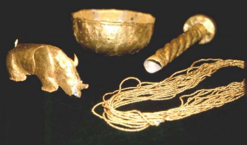
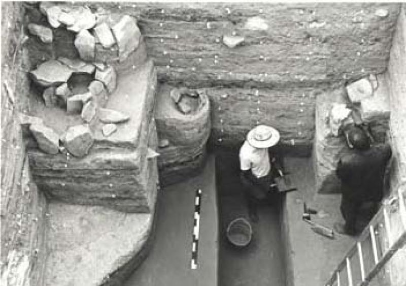

The Mapungubwe Cultural landscape records the sequency of social and economic changes between AD900 and AD1300 that reflect the evolution of class distinction and sacred leadership in the settlements known as Schroda, K2 and Mapungubwe. These are the only places where exotic trade and non-utilitarian items have been found in such large quantities in South Africa.
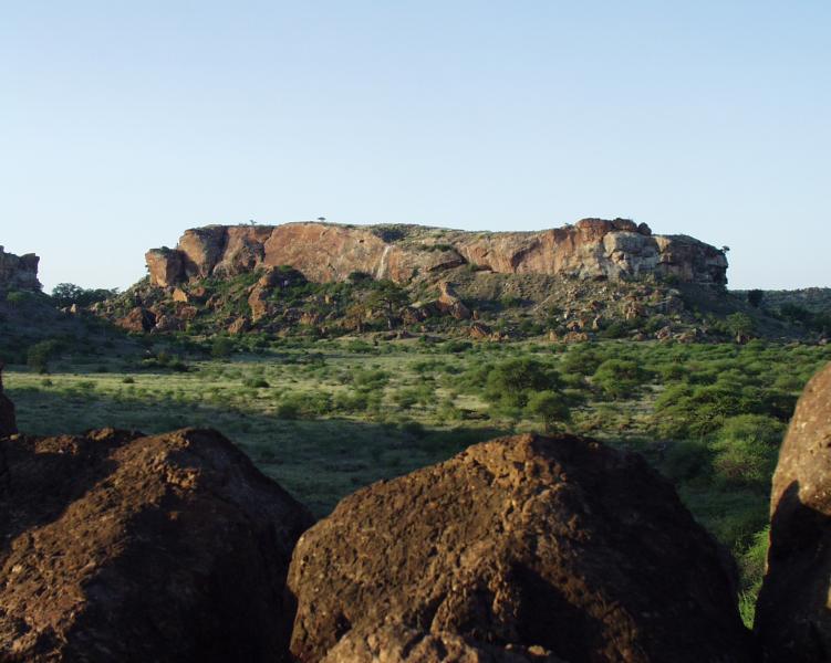
Mapungubwe Hill and the surrounding terraces below it were occupied mainly between AD 1220 and AD 1290 at a time when the Mapungubwe culture was at its zenith. It is the best known example in this cultural landscape of the effects of accumulated wealth on social stratification that led to separation of the ruling class from the commoners. The elite hilltop settlement, with royal graves, gold, copper and other ceremonial artefacts and trade goods, is physically and cognitively distinct from larger commoner agricultural settlement at the base of the hill. Wealth in the ruling class grew from trade with the east coast of Africa and the Indian Ocean network centuries before Europeans found the sea route to India. While ideal climatic conditions for agriculture prevailed in the thirteen century, Mapungubwe was the centre of the first powerful indigenous kingdom in Southern Africa.